 |
| About Bioline | All Journals | Testimonials | Membership | News |
|
||||||
|
||||||
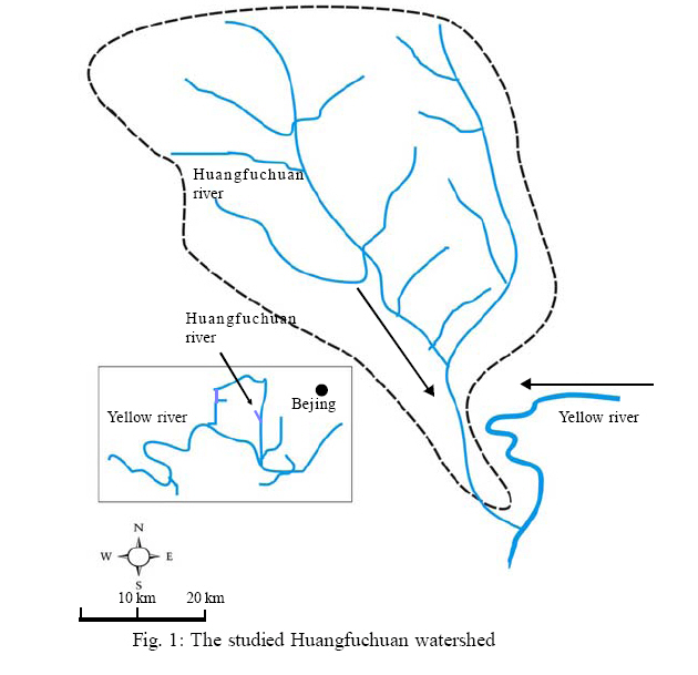
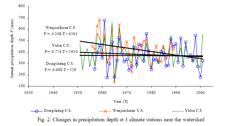
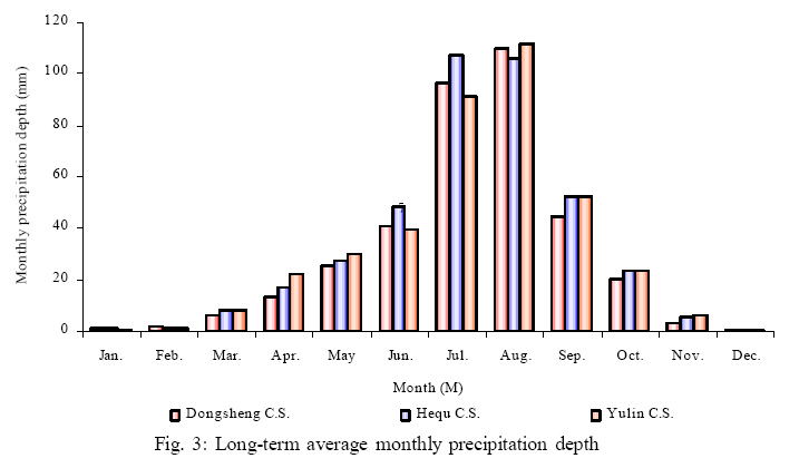
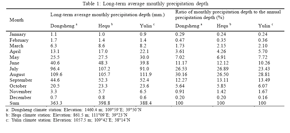
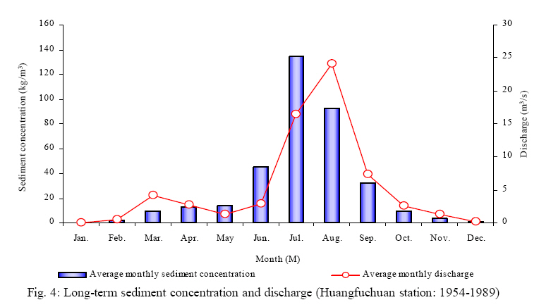
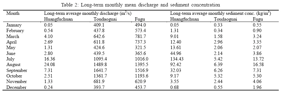
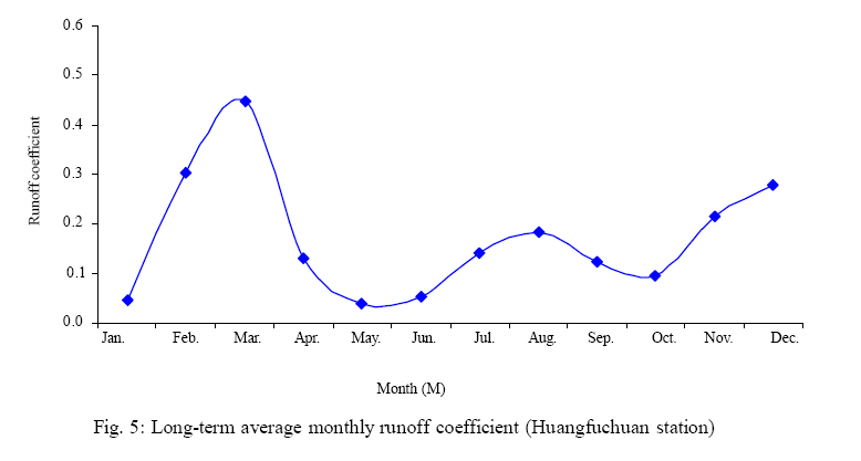
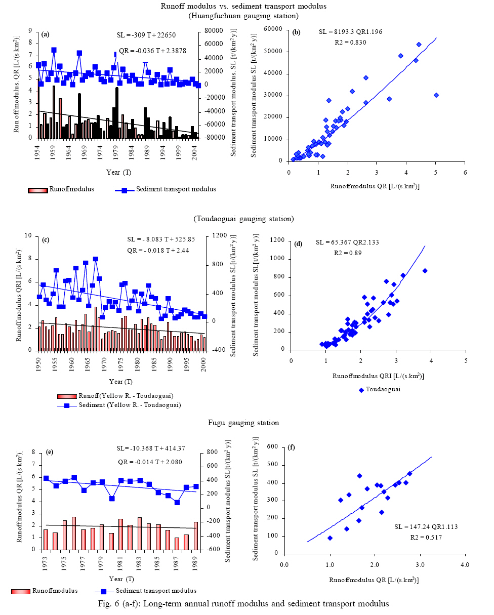
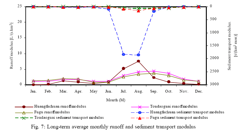
International Journal of Enviornmental Science and Technology, Vol. 5, No. 2, Spring 2008, pp. 149-160 Flow and high sediment yield from the Huangfuchuan watershed 1*J. Sui; 2Y. He; 3B. W. Karney 1Environmental Engineering Program, University of Northern British Columbia, Prince George, BC, Canada, V2N 4Z9 Received 19 October 2007; revised 25 December 2007; accepted 18 January 2008; available online 10 March 2008 Code Number: st08018 ABSTRACT This study deals with general features of sediment transport in the Huangfuchuan river, an important branch river of the Yellow river, draining the Loess Plateau in China. The long-term precipitation records at 3 climate stations near the watershed have been used to assess the changes in precipitation in this region. By introducing metrics for runoff and sediment transport, long-term observations on discharge and sediment concentration at the Huangfuchuan gauging station on the Huangfuchuan river have been used to assess the changes in runoff and sediment transport in the Huangfuchuan River compared with those at the Toudaoguai and Fugu gauging stations on the Yellow river. It is found that both runoff and sediment metrics have a clearly downward trend. From July to August, the long-term sediment transport modulus at the Huangfuchuan gauging station is much higher than those at the Toudaoguai and Fugu stations on the Yellow river. The long-term average sediment transport modulus at the Huangfuchuan gauging station are high, ranging from 14000. t/(km2 y) but decreasing to 5900 t/(km2 y) over the last 10 years . Additionally, analyses on grain size distribution of suspended load in the Huangfuchuan and Yellow river have been conducted. Keywords: Grain size, loess plateau, precipitation, runoff modulus, sediment transport modulus, soil erosion, Yellow river INTRODUCTION Soil erosion is a worldwide problem that threatens two important and non-renewable resources, farmland and surface water quality. Soil erosion, involving the detachment and movement of particles by both wind and (more importantly) water, deteriorates the ecological environment and restricts rural economic development. The soil erosion process can be accelerated by human activity such as the removal of surface vegetation, forest harvesting, rangeland grazing, and urbanization (Xu, 2003; Yang et al., 2004). Forest harvesting equipment, mining activities and construction equipment all disturb the soil structure and thus reduce the soil’s resistance to detachment. Soil erosion leads to silt up in river channels and reservoirs. As reported by CAHE (1992), the river bed in the lower reaches of the Yellow river has elevated from l.9 to 3 m over the past 50 years, thereby threatening to cause ever more serious flood disasters. Sediment transport in rivers is particularly important for the global geochemical cycle and the transport of organic carbon from the land to the oceans by the rivers (Ludwig et al., 1996). Sediment transport in rivers is a complex process, depending on both sediment properties (density, shape, etc.) and hydraulic parameters (Wang and Dittrich, 1999; Wang and Wu, 2001).As pointed out byWalling (2003 and 2006), the land-ocean transfer of sediment by rivers is a key component of the global denudation system and provides a general measure of the rate of denudation of the continent. With the specter of global change, many researchers have attempted to assess the changes in runoff and sediment transport by rivers. Existing research results indicate that sediment transport by rivers has tended to decrease globally in recent years. Walling (2003, 2005 and 2006) carried out extensive investigations to assess the changes in annual runoff and sediment transport modulus measured at the most downstream gauging stations on 142 world rivers. He showed that rivers with the increasing, decreasing and stable annual runoff accounted for 8.5%, 22.5% and 69.0% of the total, respectively. In the case of sediment transport, rivers with increasing, decreasing and stable annual sediment transport modulus accounted for 2.8%, 47.9% and 49.3% of the total, respectively. The Loess Plateau in China is crucial to the Yellow river watershed due to its contribution to the high sediment concentration in the Yellow river (Sui et al., 2000 and 2005; Wang, et al., 1999). The Loess Plateau has a greatly varied and rolling surface with a large topographic relief, a deep layer of loess, a loose layer of soil, a fragmented landform and sparse vegetation (CAHE, 1992; Gu, 1994; Xu and Zhang, 2006). These spectacular features lead to serious water-soil loss, making it one of the main sources of floods and high sediment concentration of theYellowriver with an averagesediment concentration of 35 kg/m3 (CAHE, 1992). As claimed by Liu (1985) and Zhu et al. (2004), the annual soil loss from Loess Plateau ranges from 200 to 30,000 t/km2. It is generally estimated that the area of high sediment yield in the middle Yellow river watershed, with an annual erosion rate exceeding 1000 t/km2, extends for 430,000 km2 over a landscape which is sparsely populated and totally dissected by gullies with heights over 200 m. The purposes of this research are to investigate the general features of sediment transport in the Huangfuchuan river which is oneimportant branch river to theYellow river in Loess Plateau, based on long-term observations on precipitation, discharge, sediment concentration and grain size of suspended load in this river as well as the Yellow river. MATERIALS AND METHODS As Fig. 1 is shown, the heavily dissected Loess Plateau watershed is situated in the northern Shaanxi province but the majority of the Huangfuchuan watershed is in the inner Mongolia region. The Huangfuchuan river flows from northwest to southeast into the Yellow river. The main channel length of the Huangfuchuan river is 137 km with an average channel slope of 2.7%. The drainage area of this branch river is 3199 km2. The Huangfuchuan gauging station on the Huangfuchuan river is located 14 km upstream of the river confluence of the Huangfuchuan river and the Yellow river. Local flash floods occur in the Loess Plateau in July and August and often cause tremendous soil erosion Sui et al. (2005). On 29 July 1982, the measured discharge at the Huangfuchuan gauging station was 1100 m3/s with a high sediment concentration of 1250 kg/m3, while on 30 July 1982 the discharge was 2580 m3/s with a high sediment concentration of 1190 kg/m3. The discharge decreased to 357 m3/s with a sediment concentration of 510 kg/m3 on 4 August 1982. By 8 August 1982, the discharge of the Huangfuchuan river increased again to 1250 m3/s with a sediment concentration of 613 kg/m3 and by 15 August, the discharge had changed to 1120 m3/s with a sediment concentration of 733 kg/m3. The low discharge on 22 September 1982 still contained a high sediment load of 1070 kg/m3. The Huangfuchuan watershed can be described as “hill and gully”landscape. About one quarter of this watershed has a soil type derived from a feldspar sandstone, about one fifth is sandy loess while the remainder is loess. Soil erosion is still high but somewhat less in the loess soils. The thickness of the loess layer ranges from 20 cm to 80 cm. Precipitation data are available at Hequ, Yulin and Dongsheng climate stations which are close to the studied watershed as Fig. 1 is shown. All data series of precipitation have a period of record from 1956 to 2002. By using long-term records of precipitation at these 3 climate stations, a trend analyses has been performed and the average monthly precipitation depths have been computed. At the Huangfuchuan gauging station, available data include the annual discharge, average annual sediment concentration and median grain size. All these data series have a period of record from 1954 to 2002. The Toudaoguai and Fugu gauging stations along the Yellow river have been selected for this study, since their gauging stations are close to the river confluence of the Huangfuchuan river and the Yellow river. The distance between the upstream Toudaoguai gauging station and the downstream Fugu gauging station is 216 km. The river confluence of the Huangfuchuan river to the Yellow river is 178.3 km downstream of the Toudaoguai gauging station or 37.7 km upstream of the Fugu gauging station. Owing to the difficulties of determining sediment yields to a high degree of accuracy, erosion and sediment transport values are generally reported here to two significant figures. The observations of monthly grain size of suspended load in the rivers at these three gauging stations have short periods of record (YRCCs, 1998-2005). The record of monthly grain size at the Huangfuchuan gauging station has a period from 1966 to 1989. The record of monthly grain size has a period of record from 1963 to 1988 at the Toudaoguai gauging station, and from 1975 to 1989 at the Fugu gauging station, respectively. RESULTS AND DISCUSSION In this study, sediment transport modulus, that is, the annual suspended sediment flux per unit area in t/ (km2 y ), is used as a general measure to assess the sediment transport in the rivers. The runoff modulus, that is, the annual average discharge per unit area in L/(s.km2), is used to evaluate the changes in runoff at these three gauging stations. To assess the changes in runoff and sediment flux at these 3 stations, trend analyses on the runoff modulus and sediment transport modulus has been conducted. The dependence of the sediment transport modulus on runoff modulus has been explored for each gauging station. The monthly grain size distributions of suspended load in the Huangfuchuan and Yellow rivers have been investigated although the available data series have a shorter period of records. Precipitation in the Huangfuchuan watershed Precipitation depth is an important factor affecting the magnitude of the runoff modulus in a river system (Wang et al., 2004; Ye et al., 2004). The assessment results of long-term annual precipitation depth at 3 studied climate stations (Dongsheng, Hequ and Yulin) located near the Huangfuchuan watershed are shown in Fig. 2 and 3. It was observed that the long-term annual precipitation depth at all 3 climate stations has a decresing trend. At the Dongsheng and Yulin climate stations, the annual precipitation depth has a slightly downward trend. The annual precipitation depth at the Hequ climate station shows a clear downward tendency. Fig. 3 shows the long-term average monthly precipitation depth at these 3 climate stations. As Table 1 is shown, the long-term average annual precipitation depth at the Dongsheng, Hequ and Yulin climate station is 363.3 mm, 398.8 mm, and 388.4 mm, respectively. During summer from July to August, the precipitation depth accounts for over 50% of the total annual precipitation depth. About 80% of the total precipitation falls between June and September. The winter months from November to March account for less than 5% of the total annual precipitation depth with value of 3.6%, 4.36% and 4.53% at the Dongsheng, Hequ and Yulin climate stations, respectively. Runoff and sediment transport in the Huangfuchuan river Runoff from a watershed plays a decisive role on soil erosion. In general, sediment concentration in rivers increases with the discharge, especially during high flow period due to the increased kinetic energy of the water (Yang et al., 2005). However, in the Huangfuchuan river, extreme high sediment concentration may even occur during low flow conditions. The specific soil type, hilly-gully landscape and the localized flush floods during the summer are likely responsible for this. Fig. 4 indicates the longterm monthly mean sediment concentration and discharge at the Huangfuchuan gauging station. As mentioned above, since precipitation in this region occurs mostly in summer between June and August, the highest long-term monthly mean discharge in the Huangfuchuan river is 24.1 m3/s in August with a longterm monthly average sediment concentration of 92 kg/m3 (Table 2). However, the highest long-term monthly average sediment concentration in the Huangfuchuan river is 130 kg/m3 and occurs in July with a long-term monthly average flow of 16.4 m3/s. This desynchronization phenomenon of the highest discharge and sediment concentration of the Huangfuchuan river may be resulted from the antecedent soil moisture condition. In this region, little precipitation falls between November and May (see Fig. 2 and Table 1). The soil moisture content is low. Thus, much fine sediment is eroded through wind erosion in the windy spring season. Once the localized rainfall occurs in summer from June to August, as Fig. 5 is shown, the majority of precipitation infiltrates into the soil and does not directly contribute to surface runoff. The runoff coefficient (ratio of runoff depth to total precipitation depth) of the Huangfuchuan watershed is fairly low in May and June as Fig. 5 is shown. However, even with this relatively low discharge, extensive erosion can occur, particularly of the fine particles stored in intermittent streams. Indeed, even the Huangfuchauan river is a perennial stream that is completely frozen during winter. In August, since a lot of fine particles have already been eroded, the surface cover is greater and there is more ground water flow, sediment concentrations in the Huangfuchuan river are relatively low. Results show that the longterm monthly average discharge and sediment concentration at the Fugu gauging station which is 37.7 km downstream of the river confluence. At the upstream Toudaoguai gauging station, the highest long-term monthly average sediment concentration is 6.4 kg/m3 and occurs in August (Table 2). The highest long-term monthly average discharge of 1641.7 m3/s is in September. At the downstream Fugu gauging station, due to the impacts of sediment yielded from the local region such as the Huangfuchuan watershed, the longterm monthly average sediment concentrations are much higher than those at the upstream Toudaoguai gauging station. As Fig. 5 and Table 2 are shown, the highest long-term monthly average sediment concentration of 16.6 kg/m3 occurs in August and the highest long-term monthly average discharge of 1519 m3/s is in September. The long-term monthly average sediment concentration in July at the Fugu station is 14 kg/m3 which is fairly high. The long-term monthly average sediment concentration in September is only 9.7 kg/m3 which is much less than those in August and July although the long-term monthly average discharge in September is the highest. Runoff modulus and sediment transport modulus To compare the magnitude of sediment transport and discharge yielded from different sizes of watersheds, sediment load and discharge per unit area of watershed should be used. In this study, the annual suspended sediment flux per unit area (sediment transport modulus, t/(km2 y)) and the annual average discharge per unit area (runoff modulus, L/(s.km2)) have been used to assess sediment transport and runoff in the Huangfuchuan river compared with those at the Toudaoguai and Fugu gauging stations on the Yellow river. As Fig. 6 (a-b) indicates, runoff modulus and sediment transport modulus at the Huangfuchuan gauging station show a clear downward trend. Several factors may account for this tendency: a) The long-term annual precipitation depths at all 3 investigated climate
stations in this region have a slightly downward trend. Conceptually, the decreased
precipitation in the watershed will clearly result in a decreased runoff depth
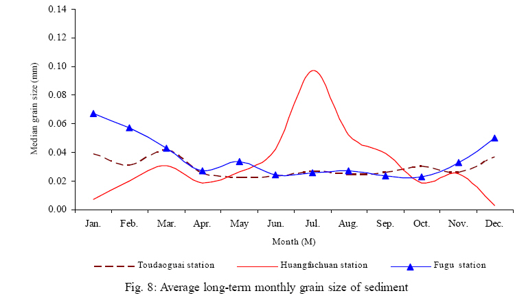
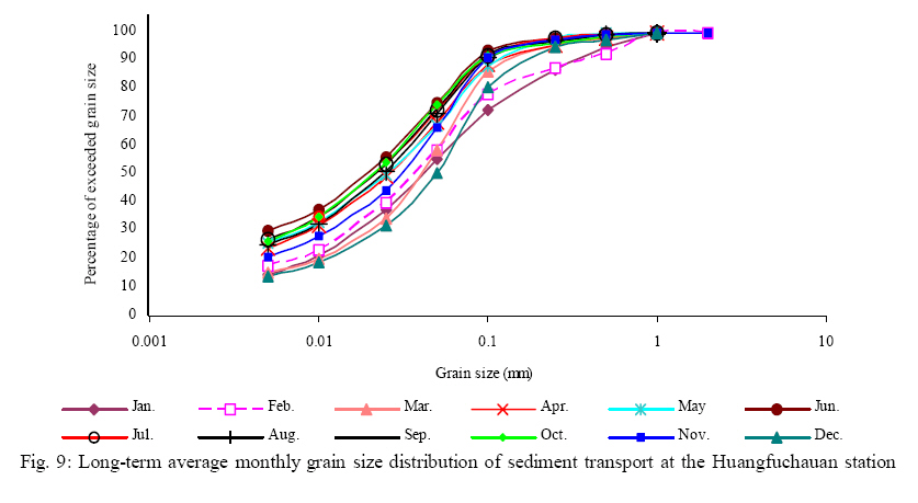
at the outlet of the watershed,and consequently decreased sediment yield. The long-term average runoff modulus at the Huangfuchuan gauging station is 1.43 L/(s.km2) and 0.62 L/(s.km2) in the most recent 10 years. The longterm average sediment transport modulus at the Huangfuchuan gauging station is 14000 t/(km2 y) that decreased to 5900 t/(km2 y) over this same period. As Fig. 6 is shown, the dependence of sediment transport modulus on runoff modulus at the Huangfuchuan gauging station is strong. To assess the impacts of sediment yield from the Huangfuchuan watershed on the sediment transport in the Yellow river, the longterm runoff modulus and sediment transport modulus at the Taoudaoguai and Fugu gauging stations on the Yellow river have been assessed. As Fig. 6 (c-f) is ahown, at the downstream Fugu gauging station, the annual runoff modulus and sediment transport modulus has a slightly downward trend with time. The average runoff modulus of 17 years (available data series from 1973 to 1989) at the Fugu gauging station is only 1.95 L/(s.km2) and the average sediment transport modulus is 320 t/(km2 y) which is also low compared with the sediment transport modulus at the Huangfuchuan gauging station. The sediment transport modulus at the Fugu gauging station has a perceivable dependence on runoff modulus. At the upstream Toudaoguai gauging station, both the annual runoff modulus and sediment transport modulus have a slightly downward trend with time. The long-term average runoff modulus at the Toudaoguai gauging station (from 1950 to 2000) is only 1.88 L/(s.km2) and decreases to 1.11 L/(s.km2) in the last 10 years. The long-term average sediment transport modulus at the Toudaoguai gauging station is 290 t/(km2 y) which is also low compared with the sediment transport modulus at the Huangfuchuan gauging station and decreased to 83 t/(km2 y) in the last 10 years. The dependence of the sediment transport modulus on the runoff modulus at the Toudaoguai gauging station is strong. The results taken from the Toudaoguai gauging station (drainage area of the Yellow river at the Toudaoguai station: 367,898 km2) and Fugu station (drainage area at the Fugu station: 404,039 km2) indicate that the impact of sediment yield from the local Huangfuchuan watershed on the sediment transport of the Yellow river is significant. The drainage area of the Huanfuchuan watershed accounts for only 8.9% of thelocal drainage area of the Yellow river between Toudaoguai and Fugu stations. The long term average sediment transport modulus (from 1950 to 2005) is 290 t/(km2 y) at the Toudaoguai station and decreased to 83 t/(km2 y) in the past 10 years. For the Fugu gauging station, the average sediment transport modulus of 17-year available data (from 1973 to 1989) is 320 t/(km2 y). Fig. 7shows the long-term averagemonthlyrunoff modulus and sediment transport modulus at these 3 studied gauging stations. The results indicate that during summer, between July and August, both the long-term runoff modulus and sediment transport modulus at the Huangfuchuan gauging station are much higher than those at the Toudaoguai and Fugu gauging stations on the Yellow river. At the Toudaoguai and Fugu stations on the Yellow river, however, the long-term average runoff modulus is highest in September. Except during summer between July and August, the longterm average runoff modulus at the Toudaoguai and Fugu stations along the Yellow river are clearly more than those at the Huangfuchuan station. The longterm average sediment transport modulus at the Huangfuchuan, Toudaoguai and Fugu stations are 100 t/ (km2 y), 6.6 t/(km2 y) and 9.1 t/(km2 y) in June, 1800 t/(km2 y), 43 t/(km2 y) and 92 t/(km2 y) in July, 1860 t/(km2 y), 69 t/ (km2 y) and 150 t/(km2 y) inAugust and 190 t/(km2 y), 72 t/ (km2 y) and 71 t/(km2 y) in September, respectively. Grain size of sediment Conceptually, any grain size of material can be carried in suspension if currents are strong enough. Sediment flux at any time and point is proportional to kinetic energy and potential energy gradient. Since the runoff modulus is different from time to time and from place to place, the grain size of suspended load also varies. The results show that the average annual median grain size of suspended load in the Huangfuchuan river has a clearly upward trend. As Fig. 6 a indicates, the longterm annual sediment transport modulus in the Huangfuchuan river has a clear downward trend. This means that the capability of sediment yielded from the Huangfuchuan watershed decreased in the past half century, especially within the last 10 years. Besides, the average annual median grain size of suspended load in the Huangfuchuan river has an upward trend. The possible reasons for this phenomenon may be the effective soil conservation methodologies, as mentioned in the last section, and the possible reduction and/ or depletion of the fine particles in this watershed. Fig. 8 shows the long-term average monthly median grain size of suspended load in the Huanfuchuan river compared with those in the Yellow river at the Toudaoguai and Fugu gauging stations. The average monthly median grain size of suspended load in the Huangfuchuan river starts to increase in June and approaches the largest size in July and then decreases in August and continues to decrease till February in the next year. However, the long-term average monthly median grain size of suspended load in theYellowriver at theToudaoguai and Fugu gauging stations is the finest between early summer and late fall. The median grain size in the Yellow river starts to increase in November and approaches the coarsest in January. To further assess the grain size of suspended load in the Huangfuchuan river, the long-term average monthly grain size distribution has been analyzed. As Fig. 9 is shown, for the same percentage of exceeded grain size, the suspended load in the Huangfuchuan river has a larger diameter during summer, i.e. from July to August, than those during winter draught period from November to March in the next year. In other words, for the same median grain size, during the period from July to August, suspended load has a clearly less percentage of exceeded grain size than that during winter. This is reasonable, since high flow during summer flood season possesses more kinetic energy and can erode and deliver larger particles. At the Toudaoguai and Fugu gauging stations on the Yellow river, however, the long-term average monthly grain size distribution is different from that of the Huangfuchuan station. It is found that, for the same percentage of exceeded grain size, the suspended load in theYellow river has a smaller diameter during summer (i.e. fromJulytoAugust) than those during winter (i.e. from November to March). It means that, for the same median grain size, suspended load during summer period from July to August has a clearly larger percentage of exceeded grain size than that during winter. This phenomenon is possibly resulted by the impacts of river ice (Sui et al., 2000, 2002, 2005a, 2005b and 2006). In winter, a long river reach upstream of the Toudaoguai gauging station and some river reaches upstream of the Fugu gauging station are normally covered by ice. The suspended load delivered during the ice period primarily originates from the bed material in virtual absence of surface runoff. A part of the finer sediment is also contained in frazil and ice cover. Thus, the sediment remaining in water becomes somewhat coarser. In March, surface runoff and soil erosion through wind will bring some sediment into the river during the thaw. It thus results in different grain size distributions of suspended load. Comparing to the results of the Huangfuchuan station as Fig. 9 is shown, for the same percentage of exceeded grain size, the long-term average monthly median grain size in the Yellow river has a clearly smaller range than that in the Huangfuchuan river. This is because the Yellow river is a perennial stream and carries a high flow during winter, while the Huangfuchuan river is normally frozen right to the river bottom with little flow during winter. Through long-term observations of precipitation, discharge and sediment at 3 climate stations and 3 gauging stations, this study assesses the changes in sediment transport in the Huangfuchuan river in Loess Plateau in China. The results show that at all of the climate stations under study, the annual precipitation depth has a slightly downward trend. During summer from July to August, the precipitation depth accounts for over 50% of the total annual precipitation while about 80% of the total precipitation falls between June and September. However, during winter (November to March), Dongsheng, Hequ and Yulin climate stations has a precipitation depth of 3.6%, 4.36% and 4.53% of the total annual precipitation depth, respectively. The highest long-term average monthly discharge in the Huangfuchuan river is 24.1 m3/s in August with a mean sediment concentration of 92 kg/ m3. However, the highest average monthly sediment concentration of 130 kg/ m3 in the Huangfuchuan river occurs in July with an average flow of 16.4 m3/s. It is found that both runoff modulus and sediment transport modulus at the Huangfuchuan gauging station have a clearly downward trend. During summer from JulytoAugust, the long-term sediment transport modulus at the Huangfuchuan gauging station is much higher than those at the Toudaoguai and Fugu stations on the Yellow river. The long-term average sediment transport modulus at the Huangfuchuan gauging station is 14000 t/(km2 y). It decreased to 5900 t/(km2 y) in the last 10 years which are much higher than those in the Yellow river at the Toudaoguai and Fugu gauging stations. The long-term average runoff modulus at the Huangfuchuan gauging station is 1.43 L/(s.km2), which decreased to 0.62 L/(s.km2) in the last 10 years. The average monthly median grain size of the suspended load in the Huangfuchuan river starts to increase in June. It approaches the largest in July, decreases in August and continues to decrease during winter period between November and February of the next year. However, the long-term average monthly median grain size of suspended load in the Yellow river at the Toudaoguai and Fugu gauging stations becomes the finest between early summer and late in fall. The median grain size of suspended load in the Yellow river starts to increase in November and approaches the coarsest in January. For the same percentage exceeded grain size, the suspended load in the Huangfuchuan river has larger grain size during summer season from July to August than those during winter period from November to March of the next year. At the Toudaoguai and Fugu gauging stations on the Yellow river, however, the long-term average monthly grain size distribution is different from that of the Huangfuchuan river. For the same percentage of exceeded grain size, the suspended load in the Yellow river has a smaller diameter from JulytoAugust than those from November to March in the next year. REFERENCES
© IRSEN, CEERS, IAU The following images related to this document are available:Photo images[st08018f8.jpg] [st08018f6.jpg] [st08018f3.jpg] [st08018f9.jpg] [st08018f5.jpg] [st08018f2.jpg] [st08018t1.jpg] [st08018t2.jpg] [st08018f7.jpg] [st08018f1.jpg] [st08018f4.jpg] |
| |||||||||
